


Top 10 Summer 4WD Trips Near Perth.
- Feb 18, 2020
- 16 min read
Updated: Mar 8, 2020
If you're a 4WD thrill seeking nut like me, you're most likely aware of the almost endless options when it comes to EPIC four wheeling adventures in Western Australia.
Our state is without doubt BIG, in fact it covers well over 2.5 million square kilometres and makes up 33% of Australia's total land mass!
Not only that.
WA has a coastline that stretches an incredible 12889km.
This leaves us with a lifetime of destinations to choose from!
For that reason,
I've put together some of my recommended 4WD locations.
If I was to be completely honest and list all of them here on this page, it would be one damn LONG list!
So,
for simplicities sake,
I'll be posting trips based on various topics.
This is the first in a series aimed at 4WD tracks that are not only close to Perth, but are also ideal for summer trips with family and friends.
Most of these trips don't require a heavily modified 4WD and are suitable for novice drivers, however track conditions change all the time, so common sense is a must.
Four Wheel Driving is obviously without risk, never attempt to drive a section of track that you are not 100% confident with. Ensure your vehicle is in good working order and that you have suitable recovery gear before departing.
Remember to take all rubbish out with you when visiting these truely unique locations and respect others while on the track.
Anyway,
enough of my rambling, lets get stuck into it!
10: Cape Arid.
You need longer than a weekend to truely enjoy this trip. It's ideally suited to at least a long weekend, preferably even longer.
You'll, first of all, need to head to Esperance (714kms from Perth.)
Add a further 360km at least to the actual 4WD part of this trip and a further 825kms for the return trip to Perth. It doesn't take an accountant to work out that it involves a solid amount of driving and fuel however, this trip takes you on an ultimate tour of the south-west region of Cape Arid National Park.
Time wise plan to spend the first night in Esperance, two nights on the tracks and a further night back in Esperance on your way back to Perth.
The coast is truely fascinating and well worth spending the time to properly explore. The tracks are reasonably easy, the camping is awesome, the scenery is incredible and features stunning coastal granite structures and beach driving (perhaps the best part of this trip is the fishing and surfing spots!)
Start at the Esperance Visitors Centre to enquire about track conditions and fees before hitting the road again to Cape Arid National Park entry (park fees apply here.)
First stop after entering the park is Springs ruin. A lookout is situated here as well as a grave!
A few kms away is the first of many campsites you'll encounter on the trip, Thomas Fishery camp. It is very small but is close to a protected beach. The next camp is just over 16kms away, Jorndee Creek campsite it's also limited to a few campers but a beach and a creek are a short walk from here.
You will need to take care when you hit the sand track above Fern Creek and Sandy Bight beach, the sand is soft and can be a bit of a challenge! Saying that though the hard, flat sand on most of the beaches are relatively easy going from Thomas River mouth to Cape Arid however, you will encounter a few rocky headlands. Always reduce your tyre pressures before attempting to drive on beaches.


GPS Waypoints:
Esperance Visitors Centre: 33º 51' 26.3" S, 121º 53' 44.02" E
Springs Ruin: 33º 58' 15.85" S, 123º 13' 22.28" E
Thomas Fishery Campsite: 33º 59' 31.6" S, 123º 13' 25.1" E
Jorndee Creek: 33º 55' 54.34" S, 123º 19' 23.57" E
Seal Creek Campsite: 33º 54' 48.6" S, 123º 19' 59.9" E
Poison Creek: 33º 54' 13.5" S, 123º 21' 05.4' E
Sand track at Fern Creek: 33° 54' 3.68" S, 123° 21' 11.15" E
Rocky outcrop (return to Poison Creek after visiting.) 33° 53' 45.19" S, 123° 22' 12.19" E
Tagon Beach: 33° 52' 55.90" S, 122° 59' 31.94" E
Dolphin Beach (walk track to beach): 33° 52' 19.88" S, 123° 0' 7.71" E
DEC run Campsite: 33° 51' 14.92" S, 123° 0' 46.48" E
Shire run Campsite: 33° 51' 13.76" S, 123° 1' 3.31" E
Mouth of Thomas River: 33° 51' 24.58" S, 123° 0' 55.02" E
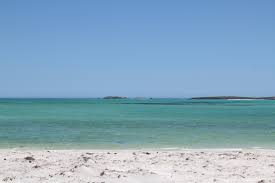
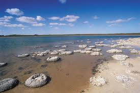
9: Cervanties & Lake Indoon.
Beach, caves, a stunning lake, fishing and bushwalking, this trip has something for everyone!
You can expect to cover at least 650kms from Perth to Perth so plan to spend around 3 days travelling as there's heaps of interesting places to visit up this way.
The starting point of this trip is Cervanties (great for fishing,) just 209kms north of Perth. Heading north you'll pass through Jurian Bay, the largest town in the central west coast and the last town to grab any last minute items you may need before heading off.
As mentioned there is a lot to see in the region, tick as many of these places off your list and if you don't get through it all, you've got a great excuse to come back during wildflower season!
This trip has a vast variety of scenery, the moonlike landscape of the Pinnacles, a 1200 year old colony of stromatolites at Lake Thetis awesome beaches at Dynamite Bay, Point Louise, Billy Goat Bay, Black Point Beach, and Sandy Cape (an awesome spot to camp but very popular and busy on weekends and holidays. Idillic lunch stops at Little Three Springs, Stockyard Gully Cave, Lake Indoon (my personal favourite campsite in the region that also provides, boat ramps, gas BBQ's and toilets. Camping fees are $5 per person per night $2.50 for seniors. The lake does not hold water all year round but is still a nice location when dry.) Hill River Mouth (be aware of the sand dune on the way in, try to avoid it by driving on the beach side if possible.) Molah Hill Lookout, and lastly Grigson Lookout.
Some of the locations mentioned will require reduced tyre pressures and 4WD as the sand can be soft at times and sharp limestone outcrops can make your drive a slow and bumpy one. Always exercise extreme care when 4 wheeling, if it looks to hard to drive, it probably is!


GPS Waypoints:
The Pinnacles: 30º 36' 16.01" S, 115º 9' 16.65" E
Cervanties: 30º 30' 7.79" S, 115º 4' 14.63" E
Lake Thedis: 30º 30' 24.71" S, 115º 4' 40.81" E
Black Point Beach: 30º 27' 14.5" S, 115º 3' 48.35" E
Hill River Mouth: 30º 23' 9.14" S, 115º 3' 0.64"E
Molah Hill Lookout: 30º 23' 42.1" S, 115º 4' 47.76" E
Jurien Bay: 30º 18' 22.24" S, 115º 2' 16.09" E
Sandy Cape: 30º 11' 5.17" S, 114º 59' 52.2" E
North Head: 30º 13' 52.89" S, 114º 59' 40.99" E
Grigson Lookout: 30º 9' 51.74" S, 115º 1' 7.4" E
Green Head: 30º 4' 11.73" S, 114º 57' 53.25" E
Point Louise: 30º 2' 52.49" S, 114º 57' 22.02" E
Billy Goat Bay: 30º 2' 31.06" S, 114º 57' 28.8" E
Little Three Springs: 29º 59' 03.2" S, 115º 05' 20.0" E
Stockyard Gully Cave: 29º 56' 30.11" S, 115º 6' 10.95" E
Lake Indoon: 29º 51' 36.64" S, 115º 9' 20" E
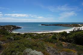
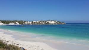
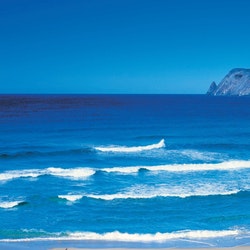
8: Wharton Beach & Cape Le Grand National Park.
Ok, so this is another trip out of Esperance, what can I say, this region was made for summer trips with family and friends.
This trip encompasses the reasons why WA's south west is so special. Bay after bay of turquoise ocean combined with a sea of granite outcrops on the land makes this area of Cape Le Grande a sight that needs to be seen to be believed!
Before I start though I have some good news and some bad news.... The bad news first, you can not "free" camp anywhere within the national park, the GOOD news however, is that you can stay at the Orleans Bay Caravan Park where you have the option of tent sites, powered sites, cabins and chalets. There is even a small shop here so roughing it you shall definitely be not! In fact this trip can easily be considered as perfect for those of you who enjoy comfort rather than the traditional "bush" style camping." That said, you will need to (possibly) engage 4WD near Hammer Head and Third Beach.
Start from the Esperance Visitors Centre and make your way to Ace of Spades Rock, this bay is amazing, keep your eyes out for dolphins!
Next stop has to be Little Wharton Beach, the drive in has some awesome ocean views. After Little Wharton Beach is Wharton Beach, from here head north for just over 4km to the entrance of Cape Le Grand National Park.You will need to keep to the marked track to access Victoria Harbour Beach. From here, head to Third beach before heading back the way you came and either camp at Orleans Bay Caravan Park, drive back to Esperance or take the long leg back to Perth.


GPS Waypoints:
Esperance Visitors Centre: 33º 51' 26.8" S, 121º 53' 42.8 E
Table Island Picnic Area: 33° 54' 34.39" S, 122° 35' 36.12" E
Caravan Park: 33° 55' 23.50" S, 122° 34' 42.75" E
Ace Of Spades Rock: 33° 56' 6.58" S, 122° 35' 22.50" E
Mount Belches Walk Trail: 33° 56' 18.41" S, 122° 35' 10.96" E
Little Wharton Beach: 33° 56' 45.22" S, 122° 33' 59.06" E
Wharton Beach: 33° 56' 20.56" S, 122° 33' 45.94" E
Cape Le Grande entrance: 33° 56' 37.91" S, 122° 31' 24.07" E
Victoria Harbour Beach: 33° 56' 46.31" S, 122° 30' 37.87" E
Third Beach: 33° 56' 11.90" S, 122° 30' 12.03" E
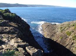
7: Broke Inlet & D'Entrecasteux National Park.
Situated just 20km south west from the town of Walpole you'll enter D'Entrecasteux Nation Park, now if your French is limited to the "excuse my French" variation of the language then you can be excused for not being able to pronounce this place correctly, [dahn-truh-ka-stoh.]
Named after French Admiral Bruni D'Entrecasteux who sailed past the region during a scientific expedition back in 1792.
The park itself stretches 130 kilometres along white sandy beaches, rugged cliffs and towering Karri forests.
A must see landmark in this region is Broke Inlet. Departing from Walpole you will pass some amazing campgrounds, a rocky headland called "Red Rock," a couple of old fishermen's huts and tackle a narrow track out towards the sea and the mouth of Broke Inlet. You will have to retake the same track back out to Walpole ones you reach the Inlet. It's a short but sweet trip best suited to a Friday afternoon escape from the city, camping at one of the campsites that night and talking in the pristine beauty of this place over two days of adventure.


GPS Waypoints:
Walpole: 34° 58' 33.56" S, 116° 43' 55.60" E
Crystal Springs Camp Ground: 34° 58' 59.09" S, 116° 36' 17.95" E
Long Point: 35° 1' 52.42" S, 116° 34' 19.60" E
Banksia Camp: 35° 0' 16.24" S, 116° 30' 43.52" E
Mandalay Beach: 35° 0' 6.43" S, 116° 32' 1.57" E
Red Rock: 35° 0' 13.87" S, 116° 31' 28.67" E
Old Hut: 34° 57' 25.58" S, 116° 27' 42.00" E
Another Old Hut: 34° 56' 39.70" S, 116° 26' 37.61" E
Broke Inlet: 34° 56' 16.46" S, 116° 22' 39.99" E
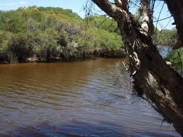
6. The EPIC Warren River!
This trip should be on your bucket list of 4WD adventures. Starting in the historic timber town of Pemberton continue south through Northcliffe and tackle the epic Callcup Hill, a 3km long soft sand hill climb! Be sure to check out Warren Beach and drive over the incredible Yeagarup Dunes before returning to Pemberton on your way back to Perth. Ideally suited to a Friday afternoon departure and staying the first night at a stunning campsite above Callcup Hill (this is one of my favourite bush camps.) Before tackling the dune the next day and heading generally northwards over a river crossing and end up at the truely remarkable Yeagarup Dunes, (you need to register your vehicle and pay a fee to enter.) A 10km drive passing Yeagarup Lake, ascend Yeagarup Dunes where you'll pass this incredible dune system that's literally swallowing the surrounding bush as it heads slowly inland. Continuing by following the marked tracks for 7kms you will arrive on the beach turn left and reach the Warren River mouth (Do not attempt to cross if running and if dry only attempt if you are 100% confident as this place is extremely dangerous!) After checking out the beach follow your tracks back out to the registration shelter head up stream to camp at a secluded campsite on the river's edge. The final day will take you over "Heartbreak Crossing" (walk this water crossing before you attempt it) and past some picturesque campsites and picnic spots along the River as you make your way back to Pemberton and back to Perth. You can expect to cover around 830 kilometres on this trip from Perth to Perth. One of my favourite trips in one of my favourite regions of WA, this is a truely 5 star trip!


GPS Waypoints:
Pemberton Visitors Centre: 34° 26' 46.29" S, 116° 1' 56.29" E
Cascades: 34º 28' 14.7" S, 116º 1' 54.48" E
Brockman Homestead: 34° 30' 19.37" S, 115° 59' 43.75" E
Callcup Hill: 34° 37' 27.33" S, 115° 52' 10.25" E
Warren River Mouth (Southern side): 34° 36' 40.13" S, 115° 49' 42.61" E
River crossing: 34° 31' 20.44" S, 115° 53' 51.83" E
Leaning Marri Campground: 34° 32' 18.51" S, 115° 52' 29.44" E
Yeagarup Registration Shelter: 34° 32' 27.89" S, 115° 52' 28.45" E
Yegarup Lake: 34° 32' 31.86" S, 115° 52' 31.59" E
Yeagarup dunes (Hill climb): 34° 32' 50.19" S, 115° 51' 44.04" E
Yeagarup Beach: 34° 35' 37.76" S, 115° 48' 32.28" E
Warren River mouth (Northern side): 34° 36' 39.07" S, 115° 49' 37.97" E
Small campite on river bank: 34° 30' 55.65" S, 115° 54' 46.76" E
Heartbreack crossing and campsite (river crossing): 34° 30' 30.27" S, 115° 56' 19.49" E
Picnic spot: 34° 30' 29.13" S, 115° 56' 18.89" E
Drafty's campsite: 34° 30' 37.17" S, 115° 56' 41.71" E
Warren Campsite: 34° 30' 34.57" S, 115° 57' 31.32" E
Warren lookout: 34° 30' 12.07" S, 115° 58' 10.46" E
Blackbutt picnic site: 34° 30' 17.81" S, 115° 58' 34.85" E
Dave Evans Bicentennial Tree: 34° 29' 44.24" S, 115° 58' 29.42" E
5. Local Surf & Turf.
Just under 100kms from Perth and 25kms from Mandurah lies White Hills, after following White Hill Road for 4kms you'll need to air down and hit the beach, turn left and you have over 20kms of beach to drive on. White Hills location makes this an ideal day trip and can easily be turned into a bush adventure too by heading west through some of WA's iconic country towns, theres even a section of track out the back of Harvey that is steep and rutted and requires 4WD. If you intend on camping, there is a campsite near Preston Beach (Martins Tank campground.)
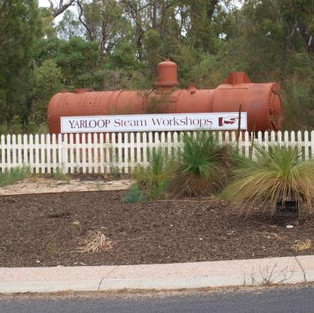
Other highlights in the area are the town of Yarloop that suffered a massive bushfire in 2016, since then the town has slowly been rebuild, well worth a look around and even stop for lunch. After Yarloop, head north to Harvey, this town is famous for it's dairy, orange and beef production.
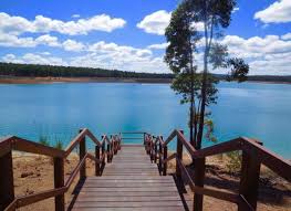
This region has an abundance of lakes, give Logue Brook Dam a visit and drive over the Dam Wall to reach a great picnic spot (although popular) known as Lake Brockman. Finally you'll pass Lane Pool camping area before heading to North Dandalup, turn right onto South Western Highway to return to Perth (72kms away.) All up you can expect to travel roughly 200kms.


GPS Waypoints:
White Hill Road (air down): 32º 41' 13.97" S, 115º 39' 37.99" E
White Hill Beach: 32º 41' 27.51" S, 115º 36' 31.91" E
Preston Beach Carpark (Air up): 32º 52' 56.77" S, 115º 39' 1.05" E
Martins Tank campground (Yalgorup National Park): 32º 50' 46.66" S, 115º 40' 4.51" E
Yarloop: 32º 57' 30.97" S, 115º 53' 57.25" E
4WD only track (Turn left of bitumen road.): 33º 0' 18.86" S, 57' 10.04" E
Logue Brook Dam: 33º 0' 13.54" S, 115º 57' 37.92" E
Picnic Area at Logue Brook Dam: 32º 59' 15.27" S, 115º 58' 48.59" E
Lake Brockman camping area: 32º 59' 15.65" S, 115º 58' 49.21" E
Lane Pool entrance (fees apply): 32º 45' 38.07" S, 116º 4' 34.16" E
North Dandalup (End of trip): 32º 31' 22.18" S, 115º 58' 11.87" E (Turn right for Perth approximatly 80km)
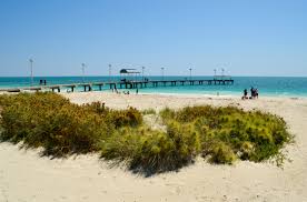
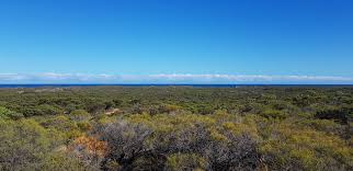
4. Northern Exposure.
North of Perth has a lot to offer the summer adventurer, you can travel for months along the North coast of WA and still not see everything. If however you just want a quick escape, this day trip should give you a good idea of what our northern coast has to offer. Starting at the seaside town of Lancelin your first mission has to be the sand dunes situated to the North East of town. Be extremely careful of other vehicles and pedestrians as this place gets extremely busy and accidents and deaths have occurred here in the past. Taking the sand tracks north of the dune system you'll find a few nice beaches such as Dide Bay, just be sure to check the tides before committing. After exploring the areas north of the sand dunes return through town and head north to the settlement at Wedge Island. I cannot express how much i love this place, the beach is amazing, the town and it's history are amazing, the residents and their stories are amazing. Do yourself a favour and visit this place before it's gone (which is a constant threat from authorities.)
Heading north once more you'll pass the tourist hotspot of the Pinnacles, worth a look if you've never been or skip it and head to Hangover Bay for a swim, fish or chillax before hitting the road to Cervanties where you'll find the incredible Lake Thetis and South Hansen Bay before swinging your rig around and heading back to Perth or alternatively turn it into a weekend getaway and spend a night or two camping at Sandy Cape.


GPS Waypoints:
Lancelin off-road area: 31º 0' 11.01" S, 19' 45.48" E
Dide Bay: 30º 56' 9.84" S, 115º 17' 19.72" E
Wedge Island Settlement and beach: 30º 49' 7.23" S, 115º 11' 26.1" E
Town of Grey and beach: 30º 39' 19.37" S, 115º 7' 57.25" E
The Pinnacles (fees apply): 30º 36' 14" S, 115º 9' 35.16" E
Hangover Bay: 30º 35' 58.53" S, 115º 6' 7.66" E
Kangaroo Point: 30º 33' 48.6" S, 115º 5' 24.37" E
Cervantes and beach: 30º 30' 33.48" S, 115º 3' 31.82" E
Lake Thetis: 30º 30' 24.71" S, 115º 4' 40.81" E
Hansen Bay: 30º 31' 14.8" S, 115º 4' 36.03" E
Sandy Cape Recreation Area: 30º 11' 4.74" S, 114º 59' 52.57" E
3. Binga and beyond.
Wilbinga is one of the most popular 4WD destinations for those living in Perth and a must for those of you who are new to four wheeling.
A short drive up the Mitchell Freeway and your transported to some of the best 4WD tracks with 100kms of the city centre.
The tracks here are mainly sand, often very soft and there are plenty of sand dunes to play in. For this reason you MUST deflate your tyres and have suitable recover gear for sand recovery (recovery boards, snatch strap ect.) Although the majority of dunes are optional and off the main track a few are unavoidable and beach access points are extremely soft. Always walk technical sections on foot before attempting to drive. A sand flag is also a great idea to allow other vehicles a greater chance of spotting you.
The entrance to Wilbinga is off Wannaroo Road, exercise extreme caution when turning off Wanneroo Road onto the dirt track and be sure to allow plenty of time for breaking and indicating before turning.
Wilbinga has a web of tracks to explore, beaches to fish, swim, SUP. In fact you could easily spend the day here and head home content however this trip can be extended to include the the northern seaside towns of Guilderton and Seabird. You will unfortunately have to travel a sort distance on the black top at times in order to continue further up the coast.


GPS Waypoints:
Entrance to Wilbinga: 31º 25' 54.0" S, 115º 39' 44.3" E
Wilbinga Shacks & Beach access: 31º 25' 58.5" S, 115º 33' 11.3" E
Beach Access (if in doubt don't attempt): 31º 25' 23.8" S, 115º 33' 00.4" E
Black top (Indian Ocean Drive, re-inflate tyres & turn left): 31º 21' 18.6" S, 115º 36' 35.5" E
Guilderton (Deflate tyres): 31º 20' 31.6" S, 115 29' 29.8" E
Lighthouse (continue north following tracks): 31º 20' 22.98" S, 115º 29' 28.58" E
Sealed road at Seabird: 31º 16' 48.19" S, 115º 26' 37.11" E
T-Junction at Indian Ocean Drive, turn right for Perth 92kms: 31º 15.61" S, 115º 29' 6.17" E
2. Fish Creek.
This is another trip to save for a long weekend, smash out the kms on Friday and camp on the Warren River leaving the next two days free to explore at a leisurely pace. Starting in the timber town of Pemberton grab a coffee and check out the visitors centre before heading south once more, be sure to stop by the Bicentennial Tree and call it a day at a campsite on Murillup Rd or at any of the campsites, caravan parks or accomodation in Pemberton.
The next day visit the Boorara Tree and Lane Poole Falls before crossing a creek crossing (not always running) and reaching Moore's Hut and camp at Coodamurrup Beach for your second night. Your final day head for Fish Creek and the Gardner River mouth where you will find a river crossing before airing up and hitting the blacktop and heading to the seaside holiday town of Windy Harbour and the amazing Salmon Beach before head back towards Perth and passing through the town of Manjimup.


GPS Waypoints:
Pemberton Visitors Centre: 34º 26' 50.2" S, 116º 01' 52.3" E
Bicentennial Tree: 34º 29' 44.11" S, 115º 58' 29.36" E
Town of Northcliffe: 34° 37' 59.18" S, 116° 7' 27.20" E
Boorara Tree and Lane Poole Falls: 34º 40' 51.15" S, 116º 14' 55.69" E
Moore's Hut and campsite: 34º 51' 39.45" S, 116º 12' 59.75" E
Coodamurrup Beach: 34º 51' 59.39" S, 116 13' 2.75" E
Fish Creek: 34º 53' 40.71" S, 116º 17' 25.43" E
Campsite near Shannon townsite: 34º 35' 42.28" S, 116º 24' 49.07" E
Windy Harbour: 34º 50' 16.75" S, 116º 1' 21.79" E
Salmon Beach: 34º 48' 54.38" S, 116º 0' 18.98" E
Manjimup (End of trip; 293km to Perth.) : 34º 14' 33.8" S, 116º 8' 38.63" E
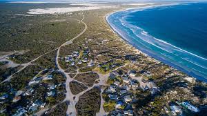
1. D'outh like a local.
You may be aware of the Cape to Cape walk track however, did you know that there is also 4WD tracks that will take you to a majority of locations along the coast that, when joined together, will take you from the Cape Naturalist Lighthouse in Dunsborough to Cape Leeuwin Lighthouse in Augusta!
BUT,
the track is not one continues track and you will need to return to the blacktop (Caves Road.) numerous times in order to continue south.This trip is around 750kms in length, if your leaving and returning to Perth, with so much to see (fishing, swimming, snorkelling, surfing) and some tracks being slow going I'd suggest you plan to spend at least 3 days exploring this truly epic region of the South West.
This trip is ideal if camping in the bush is not your thing as the region is packed with caravan parks, hotels, motels, B&B's, backpackers, farm stays and vineyards. Saying that, the campsites here are some of the best in the state so there really is accomodation to suit everyone.


GPS Waypoints:
Dunsborough: 33º 37' 2.78" S, 115º 6' 8.4" E
Bunker Bay: 33º 32' 35.02" S, 115º 2' 27.96" E
Cape Naturalist Lighthouse: 33º 32' 16.72" S, 115º 1' 7.32" E
Sugerloaf Rock: 33º 33' 35.72" S, 115º 0' 18.35" E
Bears (surf spot): 33º 34' 49.97" S, 115º 0' 50.43" E
Ngilgi Cave: 33º 38' 25.01" S, 115º 1' 59.89" E
Yallingup: 33º 38' 21.03" S, 115º 1' 33.3" E
Wilyabrup Beach: 33º 47' 33.56" S, 115º 0' 5.14" E
Calgardup Cave: 34º 2' 59.75" S, 115º 1' 28.55" E
Mammoth Cave: 34º 3' 28.73" S, 115º 1' 49.45" E
Lake Cave: 34º 4' 44.72" S, 115º 1' 45.47" E
Conto Campground: 34º 4' 53.94" S, 115º 0' 42.1" E
Conto Spring: 34º 4' 55.74" S, 115º 0' 13.32" E
Round Rock, Merchant Rock: 34º 5' 21.46" S, 114º 59' 54.92" E
Point Road Campsite: 34º 5' 37.31" S, 115º 1' 16.86" E
North Point (surf spot): 34 9' 26.74" S, 115º 1' 19.57" E
Boranup Beach: 34º 9' 41.73" S, 115º 1' 40.44" E
Boranup Campsite: 34º 10' 45.39" S, 115º 4' 7.16" E
Hamelin Bay: 34º 13' 20.26" S, 115º 1' 47.61" E
Cosy Corner: 34º 15' 21.31" S, 115º 1' 39.59" E
Jewel Cave: 34º 16' 25.75" S, 115º 5' 52.44" E
Augusta & Mouth of the Blackwood River: 34º 19' 29.55" S, 115º 10' 10.1" E
Cape Leeuwin Lighthouse: 34º 22' 25.03" S, 115º 8' 10.21" E
There you go, 10 trips that you can drive yourself this summer!
Want to add to the list? Let me know in the comments section where you've been four wheeling during summer.
Stay tuned for the next Top 10 4WD trips near Perth (coming soon) and if you want to make sure you don't miss it, subscribe to the webpage and you'll receive an email.
Oh and one last thing...
If you're a Patreon of my channel and would like turn by turn driving instructions to any of the trips listed below, let me know and i'll send them through to you.
I'm always keen to meet new faces, if your keen to join me out on the track send me a message on facebook and keep an eye out for posts on upcoming trips.
I'm also on all the other major social networks .
Cheers legends, see you soon!
Dan.
Comments